
We’re lucky to have some Great British Coastline in and around Southend. Whether it’s a short stroll, or a big adventure, we have a station and route to get you where you want to be. The total route from Shoeburyness to Leigh-on-Sea is approximately 7.5 miles and will take roughly 2.5 hours. We have also split the route into smaller chunks depending on how far you want to go. Stopping at ice cream shops, cafes, fish and chip shops and even the pub is encouraged.
Travel from London to Southend from £12.10 return with our Online Advance fare, bought 3+ days in advance. You can buy your Off-Peak tickets on c2c Smartcard, making your journey quicker and easier. Find out more about Smartcard.
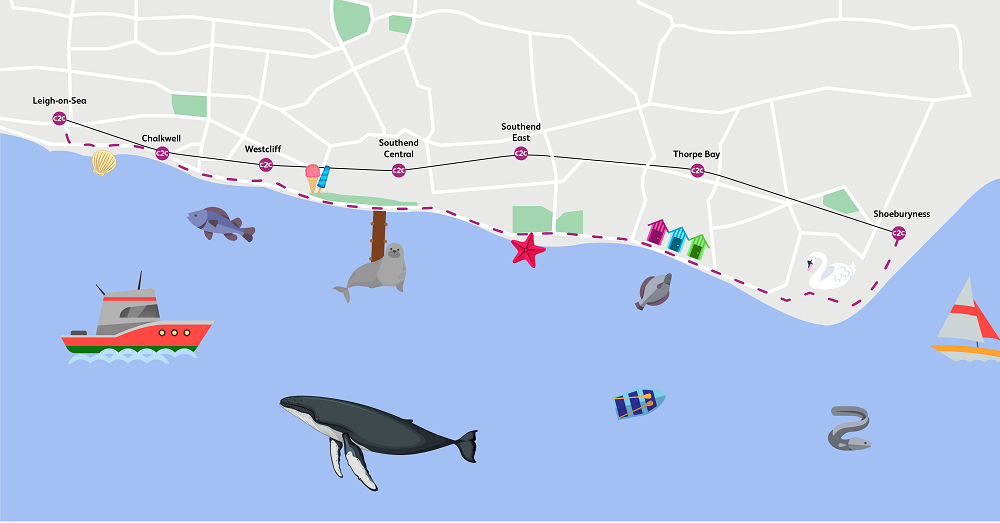
Walking route 1: Shoeburyness to Thorpe Bay (approximately 3 miles, 1 hour)
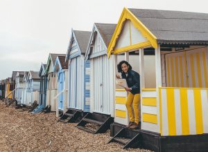
At the end of the c2c line, Shoeburyness is known for its military history and has famously been painted by J.M.W Turner. It also boasts two blue flag beaches if you fancy a paddle before you set off. From the station, cross over into the park to get your first glimpse of the coast road, then follow this down past the WWII defences. Take a quick refreshment stop at Uncle Tom’s cabin and continue on along the seafront, passing rows of brightly coloured beach huts. If you are ready to head back to the train, then just go up The Broadway to make your way to Thorpe Bay station.
Walking route 2: Thorpe Bay to Southend East (approximately 2.3 miles, 47 minutes)
If you aren’t already at the seafront, head down The Broadway and follow the coast to the right. Along the way you will see lots of pretty beach huts, and will have the opportunity to pop to a cafe (or pub) for a quick pitstop or ice cream. Head up Camper Road and cut through Southchurch park to Kensington Road to get to Southend East station.
Walking route 3: Southend East to Southend Central (approximately 1.8 miles, 37 minutes)
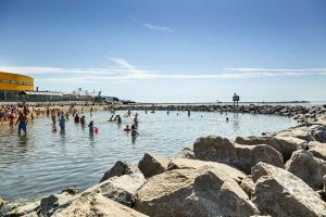
If you are coming straight from Southend East, head down Kensington Road, through Southchurch Park and down Camper Road to reach the sea front or straight down Victoria Road for a more direct route. Follow the seafront to the right (head towards Southend Pier in the distance). This part of the walk has beautiful blue-flag winning Thorpe Bay beach, one of the five beaches in the area with this honour. Stop by Sealife Adventure to say hello to meerkats, monkeys, otters, penguins and sea creatures. A little further along the front are amusement arcades, ice cream parlours, fish and chip restaurants and even places to buy famous Southend rock. Adventure Island theme park is at the end of this stretch if you’re craving an adrenaline hit. Head up pier hill or take the lift from the seafront to get to Southend high street. About a ten minute walk up the high street is Southend Central station.

Walking route 4: Southend Central to Southend Pier (approximately 3.2 miles, 70 minutes there and back)
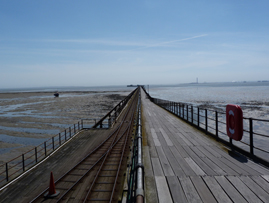
From Southend Central, head down through the high street to pier hill where you can pick up the start of the pier. The pier is the longest pleasure pier in the world, but also has a railway if you don’t feel like walking all the way there and back. Find out more about ticket prices here. Once you’ve made it to the end there are plenty of kiosks to grab refreshments – you may even see Sammy the Seal.
Walking route 5: Southend Central to Westcliff (approximately 1.6 miles, 25 minutes)
From Southend Central, head down through the high street to Pier Hill or straight down using the lift. Here you’ll find Adventure Island theme park, Southend Pier and the blue flag Three Shells Beach. Follow the palm trees and soak up the sea air. If you prefer you can walk through the Cliff Gardens running parallel to the sea. Near the end of the walk, you’ll reach legendary Rossi’s, serving Southend since 1932, where you can pick up a well-deserved ice cream whilst enjoying another blue-flag winning beach in Westcliff. Head up Seaforth Road to make your way to Westcliff station.
Walking route 6: Westcliff to Chalkwell (approximately 1 mile, 20 minutes)
As you exit Westcliff station you can see the sea down Seaforth Road. Following the sea front towards Chalkwell you will come across the Crowstone, erected in 1837 to mark boundaries in the river Thames. Head up the steps at Chalkwell station where you can still see the sea from the platform.

Walking route 7: Chalkwell to Leigh-on-Sea (approximately 1.4 miles, 30 minutes)
Head down the steps to the seafront; from here you can follow the trains all the way to Leigh-on-Sea station. As you pass the curly-wurly bridge and the yacht club you will get to Old Leigh with its cobbled streets and fishing boats. Pop into the Heritage centre or one of the many pubs (Ye Olde Smack or The Peterboat have great views of the Estuary). If the tide is out, Leigh has some great spots for wading birds such as Oystercatchers and Plovers. Carry on through Leigh and follow the row of fish and cockle sheds up to the steps of Leigh-on-Sea station.